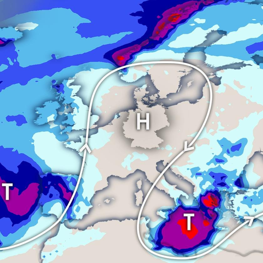
This week the weather situation is very stable. This means that rain and sunshine will be distributed quite unevenly in Europe. Why is the situation so deadlocked and what does that mean for our weather?
A stationary high will lie over Germany all week. This is flanked by a low off Portugal and another low south of Italy. The current at a height of 5 kilometers, indicated by the white line in our illustration, circles these pressure formations. The shape is reminiscent of the Greek letter Omega, which is why such a weather situation is also called “Omegalage”. Once such a flow pattern has been established, it can be very stable. This means that not much is happening in large parts of Europe this week.
Germany will now be on the sunny side for many days. Low pressure areas cannot reach Germany for the time being. It stays dry all week and the sun shines for about 13 hours every day. Occasionally loose clouds appear, but most of the time it is cloudless. In the early hours there will be local fog along rivers and lakes. It is also very warm for September. The air mass is at times 8 to 10 degrees warmer than the climatological average for this time of year (reference period 1991 – 2020). On the Rhine and its tributaries there will be highs of just over 30.0 degrees for a few days. The mark for a “hot day” is also sometimes exceeded in the lowlands of the northern half. However, the air mass is quite dry; so not sultry. This reduces the heat load. The late season has an equally beneficial effect, because with the nights getting longer and longer, the air has more time to cool down at night, so it becomes difficult to have tropical nights (not below 20.0 degrees) again. This brings with it a large diurnal temperature variation. A lot of sunshine can also be expected this week in our neighboring countries such as France and Poland, but also in the Alpine region.
Several lows are moving eastward across Scandinavia this week. Due to the traffic jam in the Norwegian Mountains, it rains a lot there. The stationary low off Portugal continues to provide the Iberian Peninsula with rainfall, although not as much water will come from the sky as during last weekend’s storms. The situation is different in the area of the stationary low over the Mediterranean. While much of the rain will fall over the sea, not all of it. It is likely to be particularly violent on Tuesday and Wednesday from Greece across the Aegean to Malta, Sicily and Cyprus! There is a threat of storms here. By next Friday, rainfall amounts of between 100 and 300 l/m² can add up. The Mediterranean water in these regions, which is far too warm, certainly plays its part. According to several high-resolution weather models, over 500 l/m² of rain can be expected in parts of Greece within a few days, and in extreme cases perhaps even up to 1000 l/m² in some places. If these scenarios come true, there will be one or two headlines about them this week.
Source : Tages Schau

